


Artículo: AMZ-B077T8PYS6
Massachusetts State Wall Map - 30.5" x 16.75" Paper
Material Type:
Paper
Detalles del producto
Disponibilidad
En stock
En stock
Peso con empaque
0.87 kg
0.87 kg
Devolución
Sí
Sí
Condición
Nuevo
Nuevo
Producto de
Amazon
Amazon
Viaja desde
USA
USA
Sobre este producto
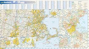
- 30.5 x 16.75 inches. Printed on paper. Flat map, tubed for shipping. This colorful, easy-to-read state map of Massachusetts identifies all major thoroughfares, secondary roads, freeway interchanges, rest areas, distance markers, landmarks, recreational areas, and more. Shaded relief on the state map provides a three-dimensional sense of Massachusetts' topography. Detailed inset maps of Boston, Lowell, New Bedford/Fall River, Springfield and Worcester are based on the latest street information from our cartographic experts. County and city indices make it simple to locate even the smallest town. Created by Globe Turner, one of the leading producers of map products in the USA.
$86,72
49% OFF
$44,47
IMPORT EASILY
By purchasing this product you can deduct VAT with your RUT number
$86,72
49% OFF
$44,47
Envío gratis
Con envío
Este producto viaja
de USA ![]() a tus manos en
a tus manos en
![]()
Conoce más detalles
30.5 x 16.75 inches. Printed on paper. Flat map, tubed for shipping. This colorful, easy-to-read state map of Massachusetts identifies all major thoroughfares, secondary roads, freeway interchanges, rest areas, distance markers, landmarks, recreational areas, and more. Shaded relief on the state map provides a three-dimensional sense of Massachusetts' topography. Detailed inset maps of Boston, Lowell, New Bedford/Fall River, Springfield and Worcester are based on the latest street information from our cartographic experts. County and city indices make it simple to locate even the smallest town. Created by Globe Turner, one of the leading producers of map products in the USA.
Compra protegida
Disfruta de una experiencia de compra segura y confiable
![]() Garantía de entrega
Garantía de entrega
Con Tiendamia todas tus compras cuentan con Garantía de Entrega o devolución total de tu dinero.
Compras 100% seguras y garantizadas, para que pidas lo que sueñas y lo recibas del mundo a tu puerta.
Tarjetas de Débito y Crédito
Visa
Mastercard
American Express
Dinners
Discover
Alias
Pagos a través de PayPal
Compra procesada en dólares con dinero en cuenta o tarjetas internacionales.
PayPal

.svg)
