


Artículo: AMZ-B0CW3P97R7
MapSherpa
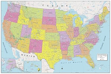
MapSherpa: United States Wall Map - Extra Large - 60 x 40 inches - Front Lamination
Size:
Front Lamination
Detalles del producto
Disponibilidad
En stock
En stock
Peso con empaque
0.87 kg
0.87 kg
Devolución
Sí
Sí
Condición
Nuevo
Nuevo
Producto de
Amazon
Amazon
Viaja desde
USA
USA
Sobre este producto
- This United States Political wall map stretches from the Pacific to the Atlantic Oceans, and the Gulf of Mexico to international neighbor borders, this US Political wall map displays all 50 states that make up the country. For readability, each state is easily identified by a different color, the map prominently shows; State capitals, primary cities & towns, major national parks, primary water features, mountain ranges and all time zones. This is the perfect reference map for home, office, or school use. Your laminated map has a glossy finish so that you can use dry erase markers on the map to highlight features, make plans, and share unique information with others. Lamination is also extremely durable, resistant to folding or ripping. Your map is rolled and packaged in a sturdy tube to protect it during shipment.
$90,68
31% OFF
$62,54
IMPORT EASILY
By purchasing this product you can deduct VAT with your RUT number
$90,68
31% OFF
$62,54
Envío gratis
Con envío
Este producto viaja
de USA ![]() a tus manos en
a tus manos en
![]()
Conoce más detalles
EXTRA LARGE WALL MAP: This wall map measures 60 x 40 inches, which is a perfect size for a wall poster collection HIGH QUALITY PRINT: Your laminated map has a glossy finish so that you can use dry erase markers on the map to highlight features, make plans, and share unique information with others. Lamination is also extremely durable, resistant to folding or ripping ROLLED IN A STURDY TUBE: Your map is rolled and packaged in a sturdy tube to protect it during shipment SCALE: 1:3,122,000 ALWAYS CURRENT: The world is always changing, and we strive to keep this map updated with these changes
Compra protegida
Disfruta de una experiencia de compra segura y confiable
![]() Garantía de entrega
Garantía de entrega
Con Tiendamia todas tus compras cuentan con Garantía de Entrega o devolución total de tu dinero.
Compras 100% seguras y garantizadas, para que pidas lo que sueñas y lo recibas del mundo a tu puerta.
Tarjetas de Débito y Crédito
Visa
Mastercard
American Express
Dinners
Discover
Alias
Pagos a través de PayPal
Compra procesada en dólares con dinero en cuenta o tarjetas internacionales.
PayPal

.svg)
